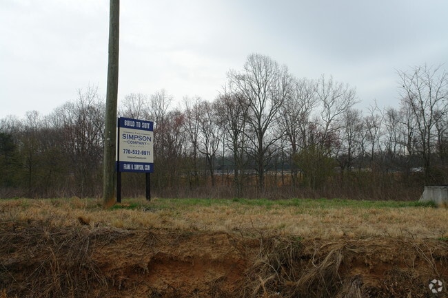
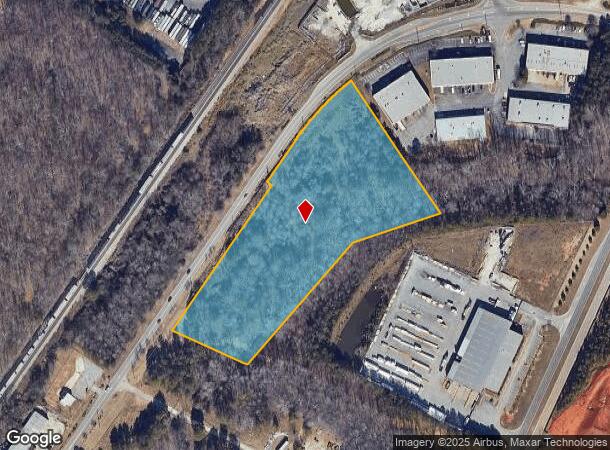
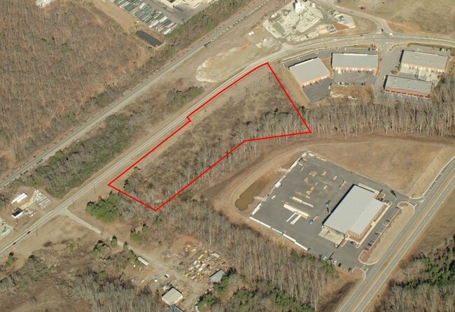
Property Record
4627 Atlanta Hwy, Flowery Branch, GA 30542
NEARBY LISTINGS FOR SALE OR LEASE
Property Detail
4627 Atlanta Hwy
Gainesville, GA
South Hall Bus Park
08-00092-00-008
SOUTH HALL BUSINESS PARK LT 5
Industrialacreage
Hall
X
Georgia
13139C0283G
5
2025
7 AC
2025
Gainesville/Hall County
001610
Atlanta
DEMOGRAPHICS near 4627 Atlanta Hwy
1 Mile
3 Mile
5 Mile
2024 Total Population
3,705
29,050
68,284
2029 Population
4,134
32,834
76,610
Pop Growth 2024-2029
+ 11.58%
+ 13.03%
+ 12.19%
Average Age
37
39
39
2024 Total Households
1,568
10,414
24,489
HH Growth 2024-2029
+ 11.48%
+ 12.92%
+ 12.16%
Median Household Inc
$68,188
$75,902
$75,512
Avg Household Size
2.30
2.70
2.80
2024 Avg HH Vehicles
2.00
2.00
2.00
Median Home Value
$273,157
$278,824
$283,515
Median Year Built
2002
1999
2000
Nearby Places
- Restaurants
- Banks
- Shops
- Fitness
- Groceries
SALE & LEASE HISTORY
LISTING DATE
SALE/LEASE

Sep 24, 2016
For Sale
Nearby Properties
Address
Land Use
TOTAL SIZE
Lot Size
Zoning
Address
Land Use
TOTAL SIZE
Lot Size
Zoning
5,760 SF
38.07 AC
R-III
Address
Land Use
TOTAL SIZE
Lot Size
Zoning
102,060 SF
31.90 AC
R-1I/H-B
Address
Land Use
TOTAL SIZE
Lot Size
Zoning
85,900 SF
25.29 AC
H-B
Address
Land Use
TOTAL SIZE
Lot Size
Zoning
164,815 SF
29.93 AC
R-IV
Address
Land Use
TOTAL SIZE
Lot Size
Zoning
150,738 SF
43.34 AC
M-1
Address
Land Use
TOTAL SIZE
Lot Size
Zoning
656,200 SF
70.29 AC
M-1
Address
Land Use
TOTAL SIZE
Lot Size
Zoning
112,734 SF
32.02 AC
R-4
Address
Land Use
TOTAL SIZE
Lot Size
Zoning
447,120 SF
35 AC
M-1
Address
Land Use
TOTAL SIZE
Lot Size
Zoning
174,720 SF
50.23 AC
M-2
Address
Land Use
TOTAL SIZE
Lot Size
Zoning
351,550 SF
26.91 AC
M-2
Address
Land Use
TOTAL SIZE
Lot Size
Zoning
104,340 SF
42.22 AC
INST
Address
Land Use
TOTAL SIZE
Lot Size
Zoning
175,622 SF
20.22 AC
M-2
Address
Land Use
TOTAL SIZE
Lot Size
Zoning
304,844 SF
37.58 AC
M-2
Address
Land Use
TOTAL SIZE
Lot Size
Zoning
269,130 SF
25.34 AC
M-1
Address
Land Use
TOTAL SIZE
Lot Size
Zoning
225,378 SF
24.42 AC
M-1
Address
Land Use
TOTAL SIZE
Lot Size
Zoning
515,468 SF
92 AC
I-1
Address
Land Use
TOTAL SIZE
Lot Size
Zoning
3,195 SF
80.04 AC
AR-1
Address
Land Use
TOTAL SIZE
Lot Size
Zoning
213,480 SF
13.16 AC
M-1
Address
Land Use
TOTAL SIZE
Lot Size
Zoning
194,748 SF
1.09 AC
PCD
Address
Land Use
TOTAL SIZE
Lot Size
Zoning
255,201 SF
21.75 AC
M-1
Address
Land Use
TOTAL SIZE
Lot Size
Zoning
183,700 SF
19.94 AC
M-1
Address
Land Use
TOTAL SIZE
Lot Size
Zoning
58.61 AC
INST
Address
Land Use
TOTAL SIZE
Lot Size
Zoning
201,322 SF
10 AC
M-1
Address
Land Use
TOTAL SIZE
Lot Size
Zoning
145,080 SF
24.51 AC
M-2
Address
Land Use
TOTAL SIZE
Lot Size
Zoning
169,345 SF
19.60 AC
M-1
Address
Land Use
TOTAL SIZE
Lot Size
Zoning
184,800 SF
15.60 AC
M-1
Address
Land Use
TOTAL SIZE
Lot Size
Zoning
148,068 SF
31.65 AC
M-1
Address
Land Use
TOTAL SIZE
Lot Size
Zoning
208,964 SF
63.46 AC
M-2
Address
Land Use
TOTAL SIZE
Lot Size
Zoning
120,204 SF
14.77 AC
H-B
Address
Land Use
TOTAL SIZE
Lot Size
Zoning
287,366 SF
61.55 AC
I-2
The World's #1 Commercial Real Estate Marketplace
Connect with us
© 2025 CoStar Group
The information above has been obtained from sources believed reliable. While we do not doubt its accuracy we have not verified it and make no guarantee, warranty or representation about it. It is your responsibility to independently confirm its accuracy and completeness. Any projections, opinions, assumptions, or estimates used are for example only and do not represent the current or future performance of the property. The value of this transaction to you depends on tax and other factors which should be evaluated by your tax, financial, and legal advisors. You and your advisors should conduct a careful, independent investigation of the property to determine to your satisfaction the suitability of the property for your needs.